
View of the town of Narsaq from aircraft collecting hyperspectral data in South Greenland (Credit: Ministry of Mineral Resources).
In 2019, ASL entered into a contract with the Greenland Ministry of Mineral Resources (MMR) to process and analyze a large amount of airborne hyperspectral data over Gardar Province in south Greenland. The airborne data was collected over the Ilímaussaq intrusion and Igaliku Igneous Complex. The survey area is known to be rich in rare earths, but also contains underexplored segments of interest to mineral prospectors.
ASL generated mineral maps for high priority areas which in turn are to be used to support revision of geological knowledge and geoscience information for the mineral exploration industry.
Project services included:
Alunite-Kaolinite-Pyrophyllite.
The use of ASTER data in mineral prospecting has increased in recent years because of its relatively low cost, broad coverage, and unique spectral bands that are highly sensitive to alteration minerals, such as iron oxides, siliceous rocks, carbonates, sericite, illite, alunite, and kaolinite.
ASL offers a suite of standard products that can be used to broadly delineate these mineral zones or assemblages.

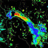
Changes at the Uvanas uranium mine between 2004 and 2008.
Kazakhstan is a large and rapidly growing uranium distributor. For planning and monitoring purposes, it will be important to map the existing and planned uranium mines across a very wide area of the country. This can be done using open-source data and detecting surface changes over wide areas using time series of low-resolution satellite images such as Landsat. A pilot project was performed in 2008 for the Canadian Nuclear Safety Commission that tracked mine development at the Uvanas Mine between 1972 and 2008.
Similar studies have been completed for other such mines using a variety of multispectral and hyperspectral imagery.
Services provided:

Hyperspectral mapping of geology at Cuprite, Nevada, with CASI and SFSI-2 fused data.
In the late 1990s Borstad Associates acquired the experimental ShortWave Infrared Full Spectrum Imager (SFSI) airborne hyperspectral imaging system, on loan from the Canadian government. At the time, SWIR imaging from airborne platforms was in its infancy, and Borstad Associates were among the first to test and develop such a system for commercial applications. Several modifications to the instrument optics, data acquisition hardware and software, as well as navigation and stabilization systems, were made and the instrument was renamed SFSI-2.
Test flights were conducted over well-known geological targets such as Cuprite, Nevada, and eventually the SFSI-2 was used in a number of surveys for industrial clients including Barrick, Placer Dome, Cominco and others.
Contact
For more information about our remote sensing capabilities, click here
ASL Environmental Sciences #1-6703 Rajpur Place V8M 1Z5 Saanichton, BC
Canada
Phone: +1 250-656-0177
Email: [email protected]
Website:www.aslenv.com
