WERA
(Product Representative)
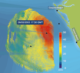
WERA is an Oceanographic HF Radar providing simultaneous measurement of:
- Surface currents maps
- Ocean waves parameters and maps
- Wind direction (wind speed under development)
These measured data are available
- Over long distances (more than 200 km) and large areas with good temporal resolution (complete data set within less than 10 minutes)
- with high spatial resolution (down to 250 m)
- Feature List (Click here)
Principals of Operation
The WERA system (WavE RAdar) is a shore based remote sensing system using the over the horizon radar technology to monitor ocean surface currents, waves and wind direction (Gurgel, 1999). This long range, high resolution monitoring system operates with radio frequencies between 4 and 50 MHz. A vertical polarized electromagnetic wave is coupled to the conductive ocean surface and follows the curvature of the earth.